|
The Roman Road from Wigan to BurscoughMargary Number: 702aaDistance: Wigan to Burscough 10.5 miles (Burscough to Hesketh Bank 9 miles)The long suspected fort at Burscough has now been confirmed by excavation (Stephen Baldwin, CBA NW Conference 2018) and by geophys (Wigan AS, Bill Aldridge). However, as the site is currently unlisted and therefore unprotected, its precise position has been requested to be kept secret. It would undoubtedly have been connected to Wigan by a Roman road and just such a road can be postulated with reasonable confidence. The zig-zag ascent in Up Holland, the modern road alongside Ashurst Beacon and Lowes (Green) Lane all have typical Roman characteristics. In addition, parish boundaries follow the route continuously for just over 2.5 miles. The road carrying on to Hesketh Bank is also a distinct possibility. A road south from Burscough would also be logical. The most obvious route would be approximated by the A59 and then via Margary Road 670 on the Wirral to Chester.. |
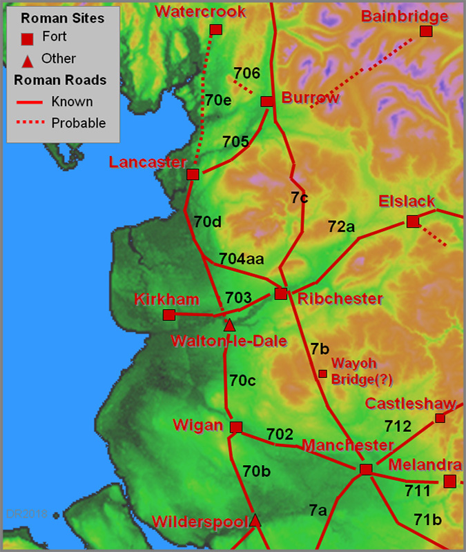
Historic County: Lancashire Current Counties: Lancashire & Greater Manchester HER: Lancashire & Greater Manchester
|
|
|
|

|
|
Lidar Image and Route Map - Wigan to Orrell The road to Burscough is highly likely to have branched off the Roman road from Wilderspool (Warrington). For the route of the latter we are reliant on Watkin (Roman Lancashire). Evidence as far as Orrell is restricted to straight modern roads (Ormskirk & Orrell Roads). |
Click for larger view |
|
First Edition OS Map - Up Holland The zig-zag ascent in Up Holland, now a footpath, is exactly how the Romans negotiated steep slopes. Note how the alignment before and after the zig-zags matches up.
|
Click for larger view |
 |
Zig-Zag Up Holland This is looking down Back Brow, the zig-zag. Halfway down is now a series of steps for those wanting a short cut. The modern road now has a huge zig-zag to negotiate Alma hill providing a much less steep ascent. I took this image many years ago and wondered about it but why would the Romans be heading west from Wigan? We now know why.
|
Click for larger view |
 |
Lidar Image - Ashurst Beacon From Up Holland to Dalton the road adopts the high ground alongside Ashurst Beacon - an expertly chosen route. It is made up a of a series of straight alignments and is typical Roman engineering. Parish boundaries follow much of it.
|
Click for larger view |
 |
Route Map - Orrell to Dalton Map corresponding to the Lidar image above.
|
Click for larger view |
 |
Oblique 3D Lidar Image - Ashurst Beacon This is an animated gif with and without the Roman road route overlaid. |
Click for larger view |
|
Beacon Lane The lane does have several Roman characteristics ie in keeping to high ground and right is just one of the several straight alignments. On this length it has an open ditch on its right (north) side. From here, parish boundaries follow the route for just over 2.5 miles - a sure sign of an old road. |
Click for larger view |
|
Lidar Image - Dalton to Burscough The route is fairly obvious for all but the last mile. The crossing a Slate Brook, a tributary of the River Tawd, stands out with a cutting to descend down. After crossing the brook it appears the Roman line is just south of the modern track. The final approach to the fort has been deleted so as to protect its location. |
Click for larger view |
 |
Route Map - Dalton to Burscough Map corresponding to the Lidar image above. |
Click for larger view |
 |
First Edition OS Map - Lathom House Lowes Lane (now called Green Lane) is a large track apparently going nowhere. Our road from Wigan probably continued in use serving Lathom House, formerly the most prestigious country estate in Lancashire. It was the last Royalist stronghold in Lancashire during the English Civil War and was twice besieged by Parliamentarian forces. It was demolished in 1925. Note: the "lines" shown on this map are probably avenues for the house. At first glance it would appear that Green Lane must be later than the lines. However, the clue is very likely in their name - they are not called avenues but lines. They appear to be setting-out lines for a grand landscaping plan for Lathom House that never came to fruition. My interpretation is that they were trenches marking where avenues were to be constructed and planted. This clearly never happened - all we have is lines or shallow ditches. If they had been constructed then Green Lane would have been diverted away from the estate as has happened at other stately homes such Rufford New Hall (below) and Leighton Hall.. |
Click for larger view |
 |
Green (Lowes) Lane - Drone Image The size of Lowes/Green Lane is clear from this drone shot. Image: Bill Aldridge |
Click for larger view |
 |
Green (Lowes) Lane Ground level view of the lane showing its large construction, built-up agger with side ditches. The left hand ditch does however appear to have been widened for drainage in modern times. Image: Bill Aldridge |
Click for larger view |
 |
Route Map - Wigan to Burscough Full route map for the Wigan to Burscough section. However, it or another road, appears likely to have continued on to Hesketh Bank. |
Click for larger view |
 |
Oblique 3D Lidar View - Burscough to Hesketh Bank The location of a fort at Burscough now starts to make more sense. North of it today are the reclaimed lands formerly of the Ribble Estuary. Heading north is a narrow promontory of high ground going via Rufford and Tarleton to the old ford at Hesketh Bank. This forms the only dry route north and reaches the Ribble Estuary opposite Kirkham. So we have a logical location for both Burscough and Kirkham!
|
Click for larger view |
 |
Lidar Image & Route Map - Possible Road to Hesketh Bank The route follows the narrow promontory of high (and dry) ground. It is generally followed by modern roads but in two places, north of Rufford and south of Tarleton, it diverges so can be seen in the Lidar data.
|
Click for larger view |
 |
Lidar Image & Route Map - Rufford This is the first real evidence for the road as the modern A59 swings away off the probable Roman line. North of Rufford New Hall there appears to be a modern pipeline alongside the old road just to confuse the issue here but the road alignment is further west.
|
Click for larger view |
 |
Aerial Photograph - Rufford This is the area north of Rufford New Hall. My guess is that this is the line of the original road with the modern A59 being a later turnpike bypassing Rufford New Hall. If so it could well be derived from the Roman road.
|
Click for larger view |
 |
Lidar Image & Route Map - Tarleton Approaching Tarleton the modern A59 again swings off line. This stretch I would also suspect was replaced by the turnpike so almost certainly the old route and lines up perfectly with the straight road through Tarleton.
|
Click for larger view |
 |
Hesketh Bank Through Tarleton the road is very direct and straight making a beeline for the old fording point. This is where the road suddenly drops down to the old shore which would have been where the T-junction is (big arrows). This point is opposite to Kirkham and was in the past the old fording point for the Ribble Estuary. There is a guide house hereabouts. Travelers would have needed a guide to cross the dangerous estuary. Note: what looks like a Roman milestone is a much later stone post. It fooled me until I took a closer look.
|
Click for larger view |
 |
Lidar Image Ribble Estuary - Hesketh Bank & Kirkham The relationship of the road at Hesketh Bank and the fort at Kirkham becomes apparent in this lidar view of the Ribble Estuary. It is the shortest fording point for the Ribble Estuary.
|
Click for larger view |
 |

|
|
|
Last update: December 2018 |
© David Ratledge |