Roman Roads in Lancashire - Page 4 |
 |
Possible Roads |
Ribchester to Wigan(?) (20.5 miles)A few clues point to the possible existence of this road. The Antonine Itinerary gives a distance of 20 miles, which fits a direct route assuming Coccium is Wigan, which is more likely now with the discovery of the remains of a substantial bathhouse with hypocaust, in the town centre 2005 redevelopment (ref. Ian Miller & Bill Aldridge).  On the direct route are 4 occurrences of street or causeway names - see map. As yet most are best regarded as possible rather than likely indicators. If there were a road it would, more than likely, have branched off the Ribchester to Manchester road after crossing the Ribble. There are some very faint traces visible and again ascending obliquely up Mellor Hill in the Lidar imagery but really of low confidence. At Causeway Farm, near Riley Green, the ford across the River Darwen below Lodge Farm was apparently known as the "Roman Ford". Any trace of a road seems lost across the golf course but perhaps appears further north across Long Lane at Cabin Hill/Woodcock Hill (Ref: Dixon - Journeys through Brigantia - Book 11). There are some Lidar indications but not overwhelming ones. More work needed.  Possible route at Pleasington Golf Club - not convincing evidence. Click image for full sized view. Another possible candidate is the Common, Adlington, which comprises a large agger with ditches and a relatively narrow modern road. It is straight and its alignment fits with a destination of Wigan.  The Common, Adlington - looking towards Wigan Wyre to Lancaster(?) High Gate Lane, formerly Alsergate, on a very prominent agger unlike other roads in the area. Over Wyre has produced many Roman finds and coins. Mary Higham has suggested that High Gate Lane, west of Stalmine, could well be Roman on the basis of medieval references she found to a regiam viam and magnum stratum regiam called Alsergate - its former name. This would imply that it was a King's Highway of some status and therefore perhaps derived from a Roman road. High Gate Lane (itself a clue) is unlike other roads in the area being wider and built on top of a substantial agger. The modern road is also smaller than the agger on which it sits (see above) and there are prominent ditches on both sides. It is also reasonably straight. Appearance wise it is convincing but real evidence was needed. Where the modern road wobbles off to one side near the Willows, an excavation on the line was carried out by Wyre Archaeology in 2008. A clay agger and side ditch was found but there was only time to excavate half way across. On seeing the size of the trench the land owner declined further excavation.  The excavation trench across half of the agger near to the Willows in 2008. A clay agger was to be expected on the Wyre where there is a shortage of stone.
The Roman connection is further supported by coin hoards found at Preesall and Hackensall plus field names of Street Field, Street Meadow, Street Croft near the latter. This may seem strange route but if a road from a site on the Wyre to Lancaster was the aim then then this makes sense as a direct line across Pilling Moss was impracticable before it was drained. Over-sands routes have been advocated again by Higham and the over-sands route from Knott End along Pilling Sands to Cockerham was still in use around 1700. At Cockerham it would meet up with the newly discovered route of the Walton-le-Dale to Lancaster road. Garstang to the Wyre (?)The discovery of a cobbled road through Nateby by a team from Over-Wyre Historical Society has resulted in speculation as to whether there was a road between Garstang ( from the Walton to Lancaster road) and the Wyre. The road they found ran in a South-West to North-East direction behind (north of) Nateby school. Excavations revealed a cambered cobbled road of 6 metres width with side ditches - classical Roman type construction.  Very interesting Lidar image of Nateby but unfortunately no evidence for a Roman Road. Further work to extend the road suggested a route across Rawcliffe (via Crook Gate Lane) towards Hambleton and probably the Wyre. In the other direction the route they determined went via Croston Barn Road and Green Lane to join up with the north-south road near Cabus. However, Lidar imagery (see above) has failed to provide supporting evidence so at this stage the existence of this road appears unlikely. Elslack to North (?)The route was proposed by the Pendle Heritage Archaeology Group following work by them in 1989 north of Barnoldswick. The road they found went from Horton (Lancashire) towards Swinden near Stoops Hill. That would indicate that the route left the Ribchester to Elslack road somewhere around Barnoldswick rather than directly from the fort at Elslack. However, studying the Lidar imagery does not reveal anything convincing for this route. So with its odd starting point and no corroborating Lidar its existence must be considered doubtful. |
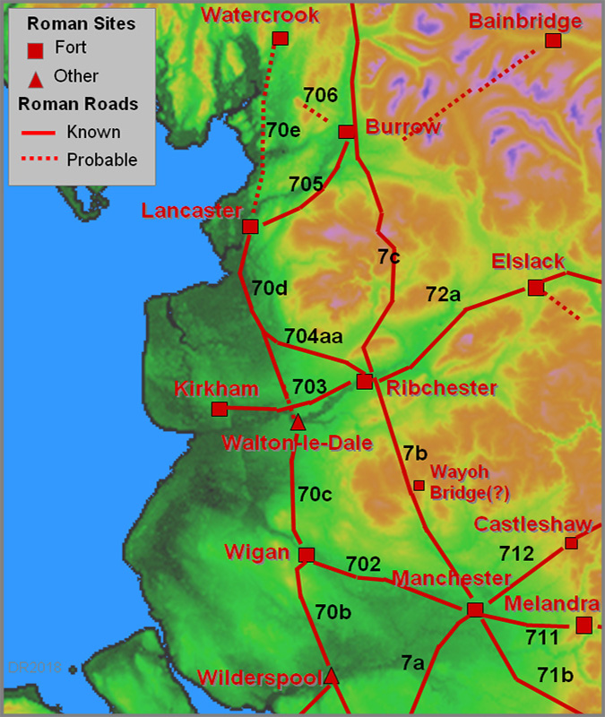 |
Greater Manchester AreaAround Manchester, extensive development has made tracing routes very conjectural. For the best guess for the central area see Manchester Roman Road map. Manchester to Chester: The A56 to Stretford (= street ford) is close to the line of the road to Chester (Margary 7a) and the stretch in the county seems to have been set out from Gorse Hill (Old Trafford) where there is a change of alignment (see below on the significance of Gorse Hill). Manchester to Melandra Castle: The A57 out through Denton would appear to be the line of road to Melandra Castle as the latest OS maps mark it as such. If so, it would appear to be a case of a turnpike road being built over the Roman alignment. This road is generally regarded as Margary 711 but he was somewhat confused describing the road heading north from Melandra towards Oldham rather than to Manchester. The fort itself does show impressively in 3D lidar - even the central building can be made out. Also obvious is a road leading out from the fort to the north-east (left).  Manchester to Buxton: This raod (Margary 71) possibly branched off the above road near Ardwick and there is the interesting possibility that it was on the same alignment as the road to Ribchester as the latter's first alignment to Affetside could have been set-out for the high ground of Hill, Heaton Moor, Nr Stockport - see contour map. The A6 probably overlies much of it now but further on at High Lane, the old road to Disley (Carr Brow-Jackson's Edge Road) marks the route. Manchester to York: The major road Chester to York via Castleshaw (Margary 712) is not represented by the A62 through Failsworth - reference Edwards. The correct line is further south and preserved in a series of minor roads, Briscoe Lane, Roman Road, The Street, Honeywell Lane (Oldham) etc.. This straight alignment appears to have been set out from Gorse Hill, Stretford all the way to beyond Oldham. (Note Gorse Hill is spelt Gaushill on OS first edition maps). The route out of Manchester to join it perhaps would have been close to Whitworth Street and Store Street. The proving of the route of this road by the 712 Group was brilliant local archaeology and is described in "Saddleworth Seven One Two". The 712 number is, of course, the reference to the number given by I.D. Margary. Recent excavations of this road have confirmed the route proposed by the 712 Group, including where they differed from both the OS and Margary in the Saddleworth area. Annoyingly the Lidar coverage runs out just before the Castleshaw fort. Below is the last available data but it does show the huge agger heading for the fort site - beyond the edge of this virtual reality model. Over the county boundary into Yorkshire more of the route has recently been found by Huddersfield and District Archaeological Society.  Manchester to Preston? The A6 north-west out of Manchester through Little Hulton and Westhoughton was considered by Watkin to be Roman. The first edition OS maps did mark it as such and there are several street and gate names along it (eg Stanney Street, Walkden and Street Gate, Little Hulton). The gate names are likely to be from the Turnpike era but the "street" names are harder to discount. However, this possible road appears to have fallen out of favour and given the amount of urban development modern evidence will be all but impossible to find now. Manchester to Wigan: This road (Margary 702) was proved by Sibson and Watkin and the route they found seems to be an example of excellent engineering being a series of straight alignments between high points on a fairly direct line to Wigan as the contour map reveals. From the Manchester fort it went south-west to Woden Ford (now Woden Street?), crossed Regent Road/Eccles New Road at a shallow angle and headed for the high ground at Hope Hall (near Hope School and Buile Hill Park). More definitely, on a slightly different alignment, it was recorded on first edition OS 6-inch maps from Hope Hall crossing Ellesmere Park to Chorlton Fold. In July 2005 the road was found in remarkable condition, less than 1 foot below the surface about 23 feet wide and consisting of small stones with a double ditch on the south side, crossing Ellesmere Park.  A remarkable case of survival - the 2005 Ellesmere Park Excavation Continuing on this line towards Worsley, then it ia still visible today in Lidar imagery crossing Broadoak Park, west of the old railway line and less certainly as far as the East Lancs Road. Just west of Worsley (SD 743008) the agger with ditches was clear in 1984 but landscaping for a golf course has removed all traces. Thanks to Patrick Maloney, Chairman of Wigan Archaeological Society for bringing this to my attention. It is also visible in Lidar crossing Mosley Common towards the guided busway.  Lidar evidence for the route near Worsley and image of the agger seen in 1984. Click image for larger view. The A577 at Dangerous Corner is taken to be the line, along Corner Lane and then along the first part of Atherton Road before it diverges away to the south side, lining in with where it was recorded crossing Amberswood Common. Wigan Archaeological Society, as part of Time Team's Big Dig 2003, excavated 3 trenches across the line and found the road and its side ditches where it crossed Walmsley Park - image1 and image2. Below are maps of the full route. The first section in Salford from Woden Ford to Ellesmere Park is un-poveable now and relies on Sibson's & Watkin's accounts.  Route from Manchester to Tyldesley. Click image for larger view.  Route from Tyldesley to Wigan. Click image for larger view. Manchester to Ilkley via Blackstone Edge: This leaves the somewhat contentious road, Manchester to Ilkley (Margary 720a), and its famous paved section over Blackstone Edge. This latter section, with a puzzling centre channel, is probably not Roman following research by Maxim (1965) who claimed to have found a medieval pack-horse track passing UNDER part of this road and therefore older than it! A more recent article in the Greater Manchester Archaeological Unit's Journal (Pearson et al., 1984/5) tended to agree with Maxim. It is therefore thought more likely the road was an early turnpike of c.1735. A little late to be Roman! The central trough is now interpreted as possibly being for cables working vehicles up the incline, evidence for this being a circular foundation block at the top and some documentary evidence in the 1734 Turnpike Act hinting at an "extra-ordinary" solution being adopted.
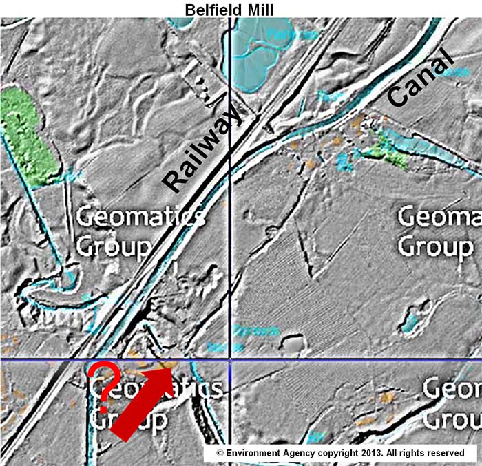
However, the story doesn't end there. Following excavations by Littleborough Historical Society, an alternative route over the Edge is looking increasingly likely. This is aligned on Swaindrod Lane and they found some evidence for an agger and ditches. This route was suggested by Donald Haigh in the 1980s, who found two lengths of agger totalling 250 metres (Greater Manchester Archaeological Journal Vol 3). Also on the Littleborough HS site is an aerial photo showing what looks to be traces of a Roman fort at Cloise Farm, Swaindrod Lane. However, the Lidar imagery doesn't appear to show anything here (probably because of tipping) but Swaindrod Lane looks convincing - well at least as far as the Lidar shows it. So it is beginning to look like there really is a Roman road over Blackstone Edge - not where everybody thought it was but 750 metres further north. Note: Swaindrod Lane seems to have 2 spellings - Swainrod/Swaindrod. Projecting this new (possible) route back towards Manchester, Donald Haigh found what he believed was a further section near Belfield Mill (see Lidar). He also mentioned evidence on this alignment at Trub Smithy and Stubley Mill but searching the Lidar imagery I didn't find anything obvious surviving in these locations. |

ConclusionIn addition to the roads described here there must inevitably have been more. For example David Shotter has recorded many coins finds in the East Lancashire area around Accrington but no roads are (yet) known here. In West Lancashire, Higham has postulated that Liverpool-Ormskirk-Hutton (A59) could be based on a Roman route from Chester. Secondary roads must also have existed bringing produce, whether from farms, industrial sites and mines, to the major centres. Lancaster to the Quernmore kilns is one suggestion. Even some of the main routes are very poorly known. There are many instances of Street names away from known roads - are any of these pointers to lost roads? However, the "Ancient Road" shown on some OS maps over Read/Padiham Heights, is probably not a road at all. Thanks to John Dixon and Brian Jeffery for drawing our attention to the geological map which shows it as old coal workings. Are there more milestones out there waiting to be discovered? However, it is not known if they were placed every mile although on the Stanegate, near Vindolanda, there are 4 successive milestones. There are still many puzzles and trying to solve them is probably the greatest attraction of Lancashire's Roman Roads. Selected References
A History of Communication In Lancashire, J M Whiteley BSc(Eng), C.Eng, MICE, FIHT former Deputy County Surveyor, Published 1984 in departmental magazine (Diversion). Ordnance Survey Map of Roman Britain - not up-to-date, has several omissions and errors but provides an overall picture. Ordnance Sheets of various scales and dates - extracts here are generally from the 6-inch First Edition of c.1845. Roman Lancashire, W.T.Watkin 1883 (reprinted 1969) Roman Roads in Britain, Codrington, 1903/1918. (Bill Thayer's excellent online version - Chapter III covers Lancashire) A Roman Road North-West from Overborough, Villy in CWAAS, 1937 - Note Overborough = Burrow. Roman Roads in Britain, I.D. Margary, 1957. Still the best source but really needs updating. The "Margary" road numbers are from this book. A Lancashire Lion, J.L. Maxim, 1965 The Blackstone Edge “Roman” road thoroughly researched by a local historian. Romans in Lancashire, D.C.A.Shotter, Dalesman Paperback 1973. Roman Manchester, G.D.B.Jones/S.Grealey, Manchester Excavation Committee, 1973. Saddleworth 712 D. Haigh, Paperback 1982. Worth downloading and keeping! Roads and Tracks of Britain, C.Taylor, Dent & Son, 1982. The Surviving Past, John Hallam (road excavation at Red Scar) Roman Fort and Town of Lancaster, Shotter and White, 1990, CNWRS Walking Roman Roads in Bowland, Philip Graystone, 1992, CNWRS The Dane's Pad (A Roman Road to Nowhere?), Ted Lightbown, 1996, The Blackpool & Fylde Historical Society. The Romans in Lunesdale, Shotter and White, 1995, CNWRS Walking Roman Roads in the Fylde and Ribble Valley, Philip Graystone, 1996, CNWRS Over-Wyre Historical Journal VII, Thompson (N), Lawrenson, Salisbury, Parkinson, Thompson (D), 1997 Romans and Britons in North-West England, David Shotter, 1993, 1997 and 2004, CNWRS. Now in its 3rd Edition and probably the best starter book. Edwards and Higham in "Leading the Way" - Ed. Alan Crosby, County Books, 1998. Ben Edwards on Roman Roads but don't miss Mary Higham's chapter which includes much Roman material. Roman Forts on the Fylde, Howard-Davis and Buxton, 2000, CNWRS The Romans at Ribchester, Ben Edwards, 2000, CNWRS Walking Roman Roads in Lonsdale and the Eden Valley, Philip Graystone, 2002, CNWRS Journeys through Brigantia Volumes 2 and 11 , John and Phillip Dixon, Aussteiger The Roman Fort at Burrow in Lonsdale, Tony Burnett, Antonine Publications The Roman A65, Tony Burnett, Antonine Publications The Ancient History of Wyre, Harris and Hughes, 2006. Towards Watercrook: Indications of a Roman Road from Lancaster, Robert Entwistle, Contrebis VOL XXXII 2008-2009 Lancaster's Roman Cemeteries, Ed. Peter Iles & David Shotter, 2009. Roman Roads & Walls in Northern Britain, John Poulter, Amberley 2010. Discovering Coccium - the Archaeology of Roman Wigan, Ian Miller & Bill Aldridge, 2011, Oxford Archaeology (but ignore the Roman Road map of Lancashire!) Sites Explored, Lancashire, David Ratledge, Britannia 2015, 2016 & 2017
CNWRS = formerly Centre for North-West Regional Studies. Now Regional Heritage Centre.
Useful Links Lancashire Old Maps This site amazingly escaped the LCC cull of historical web pages. Mario The original and still best source of Lancashire mapping and aerial photography both old and new. Huge amount of data.
Local Societies active in Roman Road research: Chorley Historical and Archaeological Society. Ribchester Local History Society
Copyright, Developments and Contacts
CopyrightAll images and text here are copyright. However, copyright is highly complex! For example, raw Lidar images are copyright the Environment Agency but the processing is copyright David Ratledge. Images are copyright David Ratledge unless stated otherwise. Developments affecting Roman RoadsFor queries on developments that might affect Roman Roads in Lancashire, please contact archaeology@lancashire.gov.uk Contact MeIf I've missed anything, got it wrong or if you have any suggestions for improving these pages, please email
It is planned to update these pages on a 6 monthly cycle so if you have reported something please be patient.
|
|
|
|
Last update: January 2018 |
© David Ratledge |