Roman Roads in Lancashire - Page 1 |

|
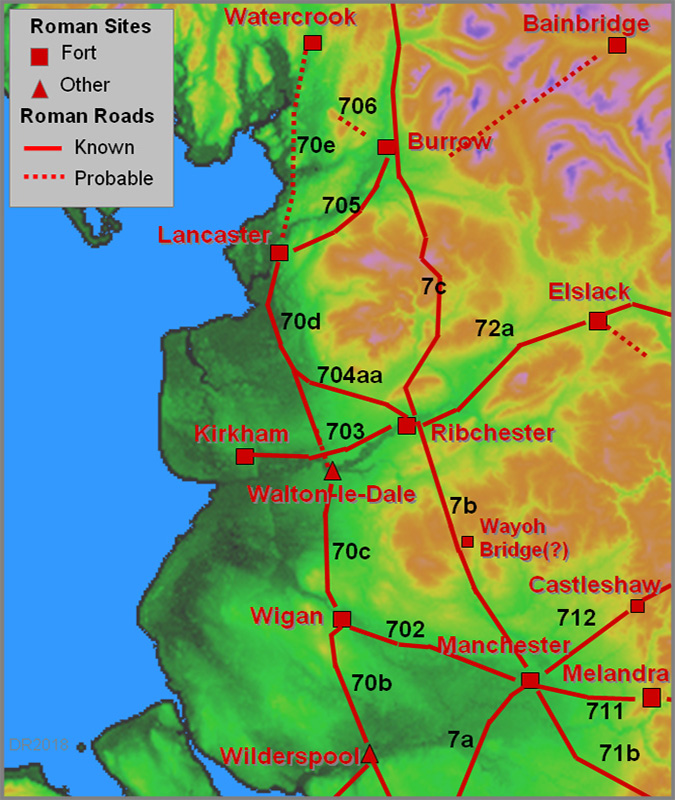
The Coastal North-South RoadWilderspool (Warrington) to Wigan, Margary 70b (13.5 miles) NEW Not strictly in Lancashire (since 1974) but included for completeness - details here Wigan to Walton-le-Dale, Margary 70c (14.75 miles)This route is never far from the A49 which is clearly derived from it although with many diversions over the centuries. The course is marked south of Wigan on modern OS maps until just south of Wigan (Goose Green) and its final alignment is to the west of Wigan. Waddelove (Britannia 2001) suggested the route continued west of Wigan and the inter visible high points of Goose Green and Standish Prospect Hill look the obvious ones but there is no evidence for this. See the link above to Margary 70b for a detailed map of how the Roman roads of Wigan relate.
 3D Lidar view from above Wigan. The fort was near the top of the hill in central Wigan and the first alignment point appears to have been on Prospect Hill at Standish. Perhaps Market Street (or possibly Mesnes Road) represents the initial line and then crossing Mesnes park. Click for larger view The Roman site at Wigan is now thought to have been a fort (ref: Miller & Aldridge). Wigan Archaeological Society have found the probable link road from Wigan to Standish near Brimelow Farm heading towards Prospect Hill, presumably to return to the main north-south alignment. A very similar arrangement exists at Ribchester with the fort site lying off the main north-south alignment.  Excavation by Wigan Archaeological Society of the road from Wigan to Standish at Brimelow Farm (looking east). Image courtesy of Bill Aldridge, WAS. Having regained the north-south alignment in the vicinity of Prospect Hill, the road would have turned turned to the north. North of Standish, Hic Bibi Lane (map and aerial-photo) is generally taken to be the line and would fit with a turn near Prospect Hill. Chorley and District Historical and Archaeological Society carried out excavations in 1959 and 1985 in the field just south of where Hic Bibi Lane reaches Coppull Moor Lane. The photo below is believed to be of the road at the north end of the field just south of Coppull Moor Lane:
 Coppull Moor Lane excavation, copyright Chorley
and District Historical and Archaeological Society
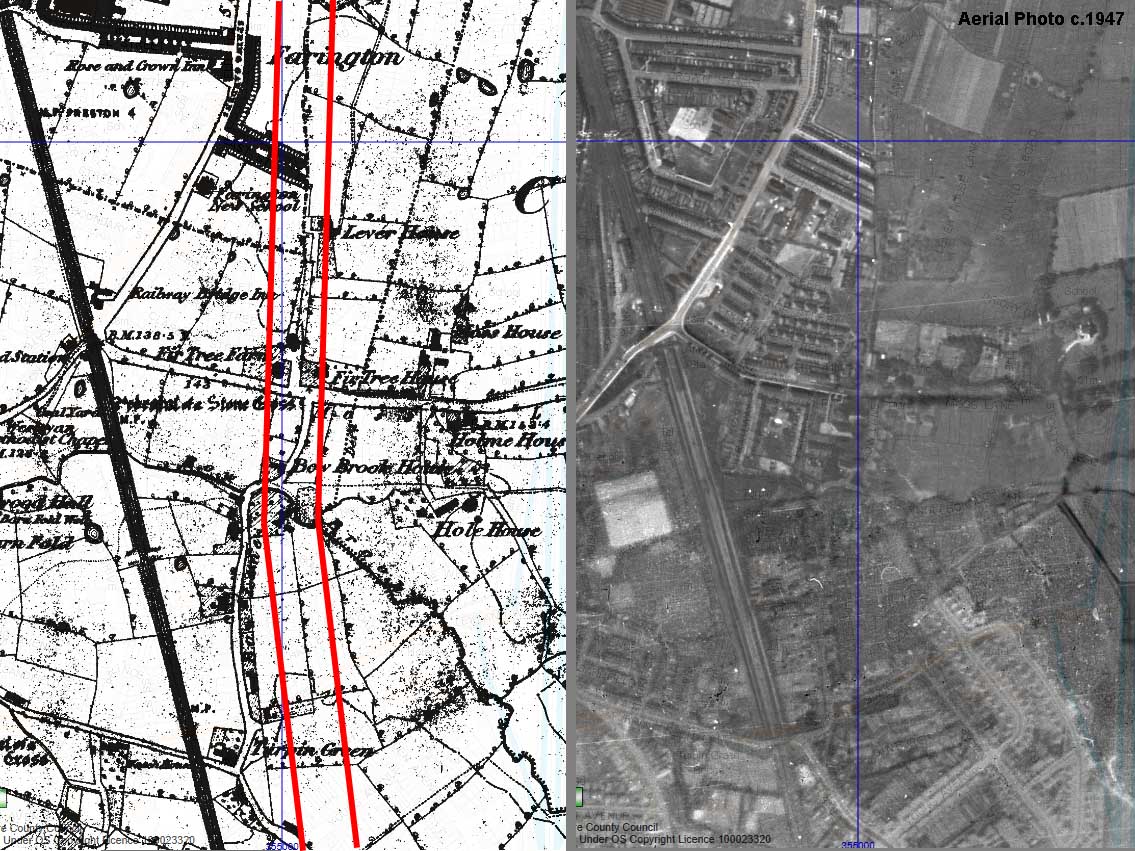
The situation from Standish to Walton-le-Dale seems, at long last, to becoming clearer. Projecting the Hic Bibi alignment to the north of Coppull then Lidar has revealed probable traces across Row High Wood approaching Clancut Brook and perhaps a dogleg to cross the valley. This is a critical piece of evidence in projecting the Hic Bibi alignment northwards.  Continuing this alignment further north would mean the road probably coincides with the A49 around Euxton Park and Hall. Further on, where the A49 turns sharply to go under Pack Saddle Bridge, new Lidar evidence indicates that it almost certainly carried straight on (see Lidar image below). There are signs both before and after the railway but the clearest is just beyond the M6 motorway.  In excavations at Walton-le-Dale (Britannia 1998) the remains of a "substantial" North-South road were found which confirmed earlier 1981-3 findings of the same road slightly further north on the site. Projecting this alignment southwards towards Leyland then it points towards Todd Lane (the site of two old crosses), Stanifield Lane and finally the A49 from Hic Bibi. Stanifield Lane is called Staniforth on the OS first edition = stone ford? On balance, a route via Prospect Hill - HicBibi - A49 - Stanifield Lane - Todd Lane now looks favourite. This route across Leyland (north of St Ambrose's Church) fits with an old track and Farington parish boundary (see map). So all things considered this is probably the best guess as to the route:  Click on map for larger view. Walton-le-Dale to Lancaster, Margary 70d (23 miles)This is one road that virtually everyone had a theory as to where it was located but evidence never seemed to be forthcoming for any of the suggestions. Lidar has revealed its true course and very little of the route found coincides with any of those previously suggested. Fowler Lane is probably the only exception. NEW - 3D Lidar videos avaailable for this road
At Preston the Ribble was crossed just downstream of London Road Bridge and the line across Preston is probably marked by Swill Brook Lane and Roman Road (that's a clue!) before crossing Church Street near Grimshaw Street. Lang's map of Preston 1774 names two fields as 'Great Pathway Field' and 'Causeway Meadow', the latter being near the site of St. Ignatius's R.C. Church. It would have changed direction here probably along the line of St. Paul's Road and Brown's map of Preston (c.1890) shows a straight boundary carrying on across what was to become Moor Park. There are 150 year old reports of the road being discovered when Lower Bank Road in Fulwood was being developed. The exact location was unfortunately not recorded - just "about halfway between Withy Trees and Fulwood Barracks". There is a possible Lidar trace across Moor Park supporting this line.  The route across Preston Beyond Watling Street Road in Fulwood, the road has been notoriously difficult to ascertain with many theories over the years but with little hard evidence. Lidar has now solved just about everything and most of the route to Lancaster can be plotted with high confidence. Having said that, the route across Fulwood is somewhat joining the dots but there is a logic to it. The alignment from Watling Street Road appears to be aiming for Banister Hill, Durton Lane - typical Roman surveying. Broughton Bypass (not shown on this map) will have destroyed a good length of the road to the east of Broughton.  Lidar provides a few clues to ascertain this line and the likely use of the high spot of Banister Hill, Durton Lane for alignment is very logical. Click for larger view. The route passing Barton is visible in the Lidar imagery from Dean Brook, Barton as far as Bilsborrow. The "chicane" south of Bilsborrow looks odd but is typical sensible Roman engineering - moving off line to negotiate slopes/valleys. So the A6 at Barton despite looking like a Roman road turns to be not the Roman line. It is in fact a turnpike road.  This stretch of Lidar evidence is so faint it is reproduced in mono here, It is definite though. Click for larger view Approaching Bilsborrow there is evidence on the ground for the road in two spots just south of Bacchus Brook, both visible from a public footpath. The fiirst is passing Anderton Fold just north of the chicane. The agger is clear passing Anderton Fold. Click for larger view The second is the approach to Bacchus Brook - a significant name perhaps? Here the road is in a cutting heading down to the brook The road in cutting on its approach to Bacchus Brook. Click for larger view Below was the key to finding the road from Walton-le-Dale to Lancaster. It was first spotted several years ago by Peter Iles on an aerial photograph. It was in a field just west of the A6 near Stanzaker Hall and, when a pipe line crossed it, a cobbled structure with ditches was found. Yet doubts still remained as to whether this was indeed Roman. There were several other candidates - one even with its own cobbled road too. But what Lidar has now revealed is that the Stanzaker Hall cobbled road is just part of an impressive length of road of unmistakable Roman characteristics. It is clear across several fields and a small wood. This settled the argument once and for all and provided a base point to work out from.  The key piece of evidence for the route just south of Garstang. From this point the road could be traced north and south. Northward from Stanzaker Hall, the road would have passed over Bowgreave hill - a probable alignment point and towards Garstang there is a very prominent lidar agger north of Castle Lane approaching the Wyre. Movements of the Wyre over the centuries means the Roman bridge site was most likely further south than where the river is today.  3D Lidar view looking south. Very obvious is the agger of the road just south of the Wyre towards Castle Lane. Click for larger view. North of Garstang modern roads probably cover its route before it makes a slight turn to the west along Fowler Hill Lane. The reason for this turn will soon become apparent.  Route across Garstang - quite a bit of interpolation but probably pretty close to reality. Click for larger image. The confirmation of the route at Fowler Hill Lane lead to the penny dropping as to the nature of the west gate post of the Turnpike Cottage at Cabus. Hiding is full view was a Roman Milestone! It so typically Roman with a square base and round top. The east gatepost here is totally different and appears banded. It looks like the turnpike trust simply commandeered the Roman milestone for use as a gate post - all they had to do was add a gate stop visible in the picture. Peter Iles was in agreement with my interpretation and has applied for it to be scheduled.  Click on map for larger view. At Cabus Cross Roads the agger becomes visible (below). It also obvious in the field behind the hedge. Beyond the canal, the Kiln Trees Lane marks the course. This has been so worn away by traffic over the centuries that it is now a hollow way.
Fowler Hill Lane at Cabus Cross Roads looking north. Amazingly, remains of the Roman agger have survived here. The reason for the turn at Fowler Hill Lane has now becomes obvious with the tracing of the course of the road south from Lancaster. Both stretches of road are aiming for Cockerham. It took me over 12 months to believe what I was finding.  Click for larger view It shouldn't have come as such a surprise. Leland's account of journey around Britain in 1539/40 includes his route through Lancashire. He was clearly still following the Roman road and his route from Garstang to Lancaster went via Cockerham. Thanks to Bill Shannon for bringing this to my attention. It also confirms that Cockerham village was at that time by the sea ("sandes").  Before Lidar, the next clue was the presence of re-located milestone at Forton Cross Roads. The route passes within about 200 metres of where is now lo be found. Lidar shows the line at Forton Hall Farm. The turn to the River Cocker Bridge and on to Main Street Cockerham is shown below. A public footpath leads down to the road through the farm yard and the road stones are clearly visible in the hedge bottom (SD 4771 5022) where the farm track has cut down through it.  The road in section at Forton Hall Farm. Click for larger view. The turn to the River Cocker Bridge and on to Main Street Cockerham is shown below. In this fore-shortened 3D view the turn looks quite sharp but in reality it is quite gentle. Note the lidar data precedes recent building work at Forton Hall which is very fortunate otherwise this turn towards the Cocker Bridge would have been lost.  The route at Forton Hall Farm. Click for larger view. The line through Cockerham must lie under the modern road (Main Street) so proof is difficult. Projecting the alignment south from Lancaster (see later) would indicate that the Roman road must turn off the modern road and head for Lancaster somewhere near Broad Gate - surely a significant name. About 300 metres to the east of Main Street ia glacial striation running north-south which would have provided an alternative route here. However, if the route of the road was to make a connection with the sea somewhere in the vicinity of Cockerham then this alternative makes little sense. On balance the road through Cockerham must be favourite particularly as in Leland's time this still appeared to be the route in use. That connection with the sea? Cockerham does seem a long way from a sea connection today but much modern land drainage has taken place. Despite modern sea banks holding the sea back, at high tide then the water still gets remarkably close - see image. After the turn for Lancaster at or near Broad Gate then the next visible agger is in the woods at Thurnham RC Church (SD46615433). It is in remarkable condition probably as good as anything on the whole length.  The agger in the woods opposite Thurnham RC Church. The arrow is pointing back towards Broad Gate. Click for larger view. The agger shown above is that arrowed on the map below. As the road leaves the wood then there is a visible spread of stones confirming the line. Beyond here when the canal was constructed the River Conder was diverted into a straight new course. The old river meander is just visible in the lidar plot (left) and is most likely where the Roman bridge would have been.  The route in the vicinity of the River Conder. Click for larger view. The following stretch at Ashton was the first one I spotted but I could not believe what I was seeing - the road should not have been heading towards Cockerham. All published wisdom had stated the road went east of Burrow Height heading due south for Galgate. Only when I realised the road coming north from Garstang was also heading for Cockerham did everything suddenly click into place. The evidence for this section is overwhelming. The lidar image (left) shows the road very clearly and is convincing enough on its own. In addition, in the field "adjoining the canal" at Ashton was found a milestone dedicated to the Emperor Philippus. The recorded a distance of 3 MP (miles) obviously from Lancaster. This all fits perfectly this road and definitely not with the previously assumed route east of Burrow Heights.
 Ashton to Lancaster section. Click for larger view. The evidence gets even stronger. Just north of the milestone find spot, when excavating the canal in 1794 the famous collection of statuary was unearthed. These are taken to be from a cemetery and/or mausoleum (ref: Shotter & Iles) and these were commonly sited alongside roads. When the road was believed to be on the east side of Burrow Heights this presented a big problem as the canal is on the west side. With the discovery of this road the problem is resolved and everything falls into place.  The road crossing the field where the statuary was found in 1794. Burrow Heights hill fort(?) is at the extreme right. Click for larger view. Into Lancaster the remains of the road have been found at the Ripley Heights and the old Royal Albert hospital. The line is not on the fort but to Penny Street and Cheapside. This was confirmed in 2005 with the discovery of the road (and a magnificent tombstone) on a development site just north of the canal at Aldcliffe.  Road into Lancaster, just north of Aldcliffe, aligning with Penny Street discovered 2005. Image Peter Iles
For a detailed map of the road from Garstang to Scotforth (Lancaster) - click below  The routes of the various Roman roads in Lancaster can now be inferred with reasonable confidence. The location of the Lune Bridge would have been south of the current course of the river and just to the east of the bus station.  Lancaster to Watercrook, Kendal, Margary 70e (20 miles approx.)The hunt is on! Evidence for a road from Lancaster to Watercrook has proved very elusive. Cumbria HER (Ref 2532) includes a possible Roman road at Deerslet, south of Burton-in-Kendal but describes it as having only "circumstantial evidence". In Lancashire, the last known course for the road is thought to be in Lancaster via Penny Street heading north to a suggested Lune bridge (see above). The most recent publication regarding a possible route for this road was by Robert Entwistle (see references).  Aerial photo looking north towards Kendal - copyright Google Earth. Click on image for larger view. To get to Kendal there are probably two options avoiding low marshy ground. The first would keep close to the coast via Milnthorpe and the second inland via Burton-in-Kendal. Leland's 1540 route from Lancaster to Kendal was via Beetham but by 1675 it would appear the inland route had taken over as Ogilby's went via Burton (map) as did the later turnpike. Nearer to Watercrook, Lidar reveals several pipelines but nothing that looks like a Roman agger. There are a few possible lines visible north of Lancaster. One via Bolton-le-Sands was excavated in November 2015 in an attempt to resolve the issue. Thanks are due to Mike Haken and Wyre Archaeology for assisting with the dig. Unfortunately the position chosen coincided with an unknown demolished farm building of some antiquity. This meant considerable time was lost getting down to the possible road layer. In the picture Mike is cleaning out was taken to be the possible east ditch of a road. The clay floor of the building can be seen as a horizontal layer much higher in the trench. Without the full extent of the feature/road being excavated no firm conclusion could be reached.  The excavation site and trench (with Mike Haken) at Bolton-le-Sands, 2015. Click on image for larger view. Lidar has so far revealed no obvious agger north of Carnforth. Sometimes, when there is no trace, it can mean that the Roman road is covered by modern roads. Do any modern roads have Roman characteristics? Well yes. If we take Leland's route via Beetham as indicating the historic route then certainly the A6 via Beetham-Milnthorpe-Haversham-Leasgill-Levens Bridge does look reasonably convincing. It is a logical route and does have the benefit of keeping a close coastal connection. This would line would indicate that the road onwards to Watercrook could be on the west bank of the River Kent. The fort at Watercrook shows up well in the 3D lidar image below. Unfortunately the road(s) do not but perhaps that is because the road from Lancaster is on the west side of the river.  Watercrook Roman Fort, Kendal. Click on image for larger view. Footnote: A route across the Sands to Furness (now Cumbria) is also a possibility and a Roman altar was found at Folly/Foley Farm, which may indicate its course - map. Continue to Page 2 |
|

|
|
|
Last update: July 2017 |
© David Ratledge |